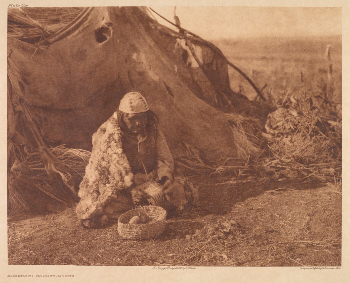
Achomawi Basket-MakerEdward S. Curtis, 1923, printed 1924 by Suffolk Engraving Co. Amon Carter Museum of American Art, Fort Worth, Texas, Purchase with the assistance of an anonymous donor, P2009.3.13.2.29.
Also find this entry through: Achomawi / Ótissi (language names with different scopes)
Achumawi histories connect distinct communities along the Pit River and neighboring northeastern California landscapes. This reading path follows band identity, spring-fed fisheries, colonial violence and survival, language teaching, cultural-resource authority, and continuing land and water advocacy. It distinguishes the language grouping from the wider Pit River Tribe and gives each source’s date and community scope.
See each region’s evidence for historical or present-day scope.
Homeland / region
California / Pit River, Fall River basin, and northeastern California
Research depth
Expanded profile
Source collection
15 annotated resources · 6 Indigenous-led
Inspected sources
15 substantive works · selected content reviewed
Initial adequacy
Not assessed
Source review
October 19, 2026
Names & relationshipsThe Pit River Tribe’s constitution describes an Ajumawi–Atsugewi Nation of eleven autonomous bands. The Achumawi language label is commonly associated with nine bands, while Atsugewi is associated with two. Ajumawi can identify a particular Fall River band; Ótissi and Pit River are language names used by the scholar cited here. Names and spellings should be attributed to their speakers and publications. Related Klamath and Modoc entries concern distinct peoples, not aliases.
An expanded introduction, with sources reviewed.This profile develops several themes through identified sources. Citations connect each section to its evidence; remaining gaps appear below. It has not been reviewed or endorsed by the community.
Backdrop photographs & credits
These photographs have individual, documented connections to this entry. Their captions and source records define the people, place, object, and period shown; no one photograph represents every community within a broader label.
Achomawi Basket-Maker Edward S. Curtis, 1923, printed 1924 by Suffolk Engraving Co. Amon Carter Museum of American Art, Fort Worth, Texas, Purchase with the assistance of an anonymous donor, P2009.3.13.2.29.
Actual complete museum catalogue body read, including title, Curtis authorship, photograph and print dates, Suffolk engraving credit, accession, inscriptions, public-domain designation and disclaimer about historical titles. Both exact archive-delivered linked JPEGs downloaded unchanged and visually inspected. The selected display image retains the complete photographic composition and printed title/credits; the second sheet-record image includes a calibration target at right. Treat this as Curtis’s historical portrayal, not a current or universally representative scene, and do not identify the unnamed sitter or assign meanings to motifs. Achomawi is the museum’s explicit people identification, not inferred from Pit River geography. No image retouching or generative content. Delivery copies are proportionally resized/recompressed from the complete archive-delivered frame. Card and page-background CSS may crop or overlay; the page banner preserves the full composition. This visual review does not increase substantive source counts or establish research completion.
Image, association, and reuse record reviewed 2026-10-25.
Full photographs are displayed proportionally above. A translucent background copy may be cropped by the viewport; it does not replace the complete image or its record.
The visual treatment does not change the research status, evidence, or remaining gaps recorded in this profile.
01
Names, language, and the scale of an account
Achumawi and Achomawi are widely used language and people labels, but their scope needs explanation. Pit River scholar Connor Yiamkis uses Ótissi or Pit River for the language associated with nine bands, while distinguishing two Atsugewi-associated bands. He explains that Achumawi is also a particular band’s name and remains a wider language name for some community members. Merriam’s 1926 fieldwork likewise records a narrower Fall River usage and different names supplied by different speakers. His historical categories and maps document an earlier research encounter; they do not settle current membership or jurisdiction. An account of one band, a language, and the eleven-band government therefore answers different questions.
The constitution published by the Pit River Tribe names the collective Ajumawi–Atsugewi Nation and identifies eleven autonomous bands. Its preamble recalls the written constitution adopted in 1964; the posted version is marked updated July 2005. The document combines shared government with local authority: the Council consists of elected band representatives, while bands retain specified responsibilities for their own cultural, religious and archaeological concerns. This political structure should not be replaced by a language classification. The constitutional homeland account also needs to be distinguished from the boundaries and title of individual present landholdings.
California State Parks' public brochure locates Ajumawi history in the spring-fed waters of the Fall River basin. It describes stone fish traps that guided fish through channels and shallow water, connecting engineering with knowledge of springs and spawning behavior. The brochure also describes limits on harvesting and protection of spawning fish. These are accounts of a managed fishery rather than a landscape untouched by people. The same publication discusses volcanic groundwater and threats to native aquatic habitat. Its account concerns this particular Ajumawi landscape; it should not become a single subsistence description for all Achumawi-speaking communities across contrasting environments.
Colonial disruption, altered landscapes, and continuing communities
The CPUC's project-specific cultural review connects nineteenth-century settlement around Fall River with retaliatory killing, Fort Crook, and forced removal to Round Valley in 1859. It also describes people returning afterward. This compressed agency history should be expanded with tribal accounts rather than treated as the experience of every family. The review traces another transformation through drainage of Big Lake, levee construction, ranching, and hydroelectric development. These changes help explain why the current wetland landscape cannot stand in for conditions before colonization. Its archaeological summaries concern surveyed project parcels, with acknowledged gaps; they cannot establish a single starting date for all Pit River history. The Tribe’s Hewisedawi page places that band around Goose Lake, the Warner Mountains and neighboring river and plateau country. It describes moving among seasonal foods before tracing how settler livestock, fencing and military violence disrupted access. Its later account follows people in less accessible places and camps near settler towns, while emphasizing survival and continuing relationships with hunting, gathering and prayer places. This is a particular band history, with its own named places and remembered experiences. It should not supply an identical chronology for every Achumawi-speaking community.
Trade networks, captivity, and the limits of inference
Layton's 1981 article places Pit River people within wider networks linking the California Plateau, Great Basin, and Columbia River. His synthesis describes exchange as well as raids and the trafficking of captives, drawing on older ethnographic and travel accounts. Those relationships varied across communities and time; they do not justify portraying neighboring peoples as permanent enemies. Layton proposes that mounted raiding could have encouraged more defensible settlements. Crucially, he says the relevant settlement research had not been conducted in Pit River territory. His archaeological comparisons from Surprise Valley are therefore a regional hypothesis to investigate, not proof that every Achumawi community followed the same sequence.
A primary tribal argument about land and cultural authority
A December 2001 letter submitted by California Indian Legal Services for the Pit River Tribe challenges proposed Shasta County land transfers. It argues that the Tribe should have been considered as a land recipient and that replacing existing protections would weaken cultural-resource care. It also objects to concentrating decisions in a nontribal archaeologist and stresses tribal knowledge of historical and intangible significance. Comment 7 specifically corrects the proposed measure's description of the Ajumawi band's relationship to the Pit River Tribe. The letter records the Tribe's position in that proceeding; it is not a finding that every legal claim was upheld or evidence of today's ownership.
Illmawi educator Connor Yiamkis and his coauthors describe turning documentation into language for ordinary household activities. The Pit River case uses breakfast vocabulary, verb forms, and conversation scripts; its Miami case concerns a different community. Yiamkis’s distinct 2025 needs analysis examines a May 2020 online survey and describes constraints on sustaining an early class. Its self-selected participants and dated program history cannot establish present fluency or the situation of every band. Together these studies show practical teaching choices and questions for later program research.
De Angulo's essay preserves reported conversations about life and relationships among people, water, trees, and rocks. The available English text appeared in 1975 as a translation of part of a 1928 French essay. Speakers' words therefore reach readers through the author's selection and a later translation, alongside his speculative theories and stereotypes. It can support careful study of how knowledge was represented in an earlier encounter. It should not define a uniform present-day belief system or authorize reproducing ceremonial instructions.
Community advocacy and the geothermal-lease dispute
The Tribe’s March 2015 hearing advisory connects its geothermal-lease appeal with water protection and continuing religious responsibilities at Medicine Lake. In a distinct November 2023 campaign release, Madesi cultural representative Brandy McDaniels explains the call for monument protection through culture, lifeways and the aquifer; citizen Radley Davis describes personal obligations to the place. These named voices show how public advocacy draws on community relationships with land and water. They establish the speakers’ positions at those dates, rather than the legal outcome of litigation, ownership of the highlands or a completed stewardship agreement. The Pit River Tribe and allied organizations challenged federal decisions extending geothermal leases at Medicine Lake Highlands. In September 2019 the Ninth Circuit affirmed a ruling against the disputed forty-year continuation of twenty-six unproven leases based on a single proven lease in their unit. The case shows sustained tribal use of federal litigation, but its precise holding concerns the leasing statute. It should not be described as a ruling that returned the highlands to tribal ownership or settled all religious-freedom and environmental questions.
On January 14, 2025, a presidential proclamation established Sáttítla Highlands National Monument on approximately 224,676 acres of federal land. Its account connects Pit River and Modoc homelands, wider Indigenous relationships, obsidian exchange, and groundwater moving through volcanic rock. The proclamation assigns management to the Forest Service and directs consultation, customary-use access, and opportunities for tribal co-stewardship. These are provisions of the designation; they do not establish completed implementation or a transfer of the entire homeland into tribal ownership. Tracking subsequent management decisions remains part of the research.
The Tribe’s August 2025 newsletter reports a Medicine Lake gathering where members and guests shared stories, traditions and language, and an Ancestral Run connecting young people with mountains and ancestors. The same issue announces a youth language camp, band elections and a Four Corners occupation commemoration. It also describes land-use planning, emergency-response investment and buffalo-herd support. This mixture makes contemporary cultural work visible alongside governmental and economic priorities. Reported gatherings differ from invitations and proposed projects: the issue alone does not establish that every announced event occurred or every construction deadline was met.
Expand band-authored history beyond the Hewisedawi account and named Madesi and Illmawi voices; one band’s experiences cannot represent all nine language-associated bands.
Examine additional primary records of settler violence and forced removal alongside community accounts, identifying whose experiences each record describes.
Document current community-led fisheries and restoration work before describing contemporary management outcomes.
Investigate the final outcome and subsequent history of the 2001 land-transfer proposal; its review and tribal objections do not establish current title.
Read the remaining sections of the language-needs study and later community program reports; early research and announcements do not establish present attendance, fluency, or program capacity.
Track implementation and subsequent policy developments after the 2025 Sáttítla designation, including actual management plans, agreements, and tribal participation.
Continue reviewing the supplied bibliography and seek community editorial review. Fifteen inspected resources are a milestone, not a completed comprehensive history.
Fifteen distinct substantive resources were inspected, with page or section limits recorded. The Berkeley navigation guide and generic 2026 language-session flyer were inspected as supporting material and remain outside this strict source count. Historical ethnography is contextualized without reproducing specialized ceremonial directions.
Follow the reading path
Sources & further reading
Open any title to read the original source. Annotations explain what each link can help you explore.
No Indigenous-led source is identified in this entry yet. This is a gap in this collection, and does not imply an absence of community knowledge or organization.
Publication: 1964 adoption; published text updated July 2005
Read the preamble and Articles I–II, VI and VII, including band powers. The Tribe publishes this text as adopted in 1964 and updated July 2005. It distinguishes the eleven-band political entity from language labels and recognizes band cultural authority. No complete 2026 legal consolidation, title survey or independent jurisdictional ruling is inferred.
Read the complete band-specific prose account, photograph caption and attribution of the appended poem. Centers Goose Lake, seasonal resources, settler livestock and fencing, military violence and continuing residence. Its chronology and ecological claims are an attributed community account, not independently established for every band. The general Tribal History page reproduces this material and is not a second counted resource.
Four-page issue read completely. Page 1 reports the July Medicine Lake gathering and Ancestral Run; pages 2–4 announce elections, language camp, commemoration, grants and community consultation. Separate reported events from invitations and planned construction. The youth camp is a Pit River-wide announcement, not proof of an Achumawi-only curriculum or measured learning.
November 1, 2023 campaign release read in full. Publishes attributed statements by Chairman Yatch Bamford, Madesi cultural representative Brandy McDaniels and citizen Radley Davis; McDaniels is identified as the Council-appointed Sáttítla working-group lead. Use as primary advocacy and personal testimony. Hydrological quantities, litigation characterizations and proposed protections need independent sources; this predates monument designation.
Actual publisher full text inspected: authorship, abstract and Pit River Case II, printed pp. 137–148, including household vocabulary, verb forms, scripts and discussion of early online teaching. Yiamkis is identified as Illmawi Band. Miami material is a separate case. Early program reports are not a current census or measured long-term outcome. DataCite DOI metadata gives 2023; public full-text access sometimes returns a bot challenge.
Inspected repository cover and manuscript printed pp. 1–9: positionality, naming, contemporary context, survey procedure and initial results. The May 2020 online survey had 76 respondents and included some non-Pit River participants; response totals vary by question. These are dated, self-selected responses, not a population census. Later interview/materials/limitations chapters await detailed inspection. Subsequent access attempts met restrictions.
Read the complete March 2, 2015 media advisory and hearing program. Documents the Tribe and allied plaintiffs publicly connecting water protection, religious responsibilities and a geothermal-lease appeal. Claims about impacts and the merits of litigation are the advisory’s dated advocacy; it does not establish the court’s decision, current lease status or later monument management.
Published December 31, 1926, pp. 1–52. Read printed pp. 1–5, 12–14, 24–26, and selected name entries on pp. 41–47 in the full scan. Merriam acknowledges named Indigenous contributors and records variable names and contrasting environments. His narrower Fall River use of A-choo-mah-we and period classification require context; the map and taxonomy do not establish present jurisdiction or modern band membership. His salvage-era assumptions should not be repeated as statements about contemporary people.
Read the HTML sections on ethnographic and archaeological background, historical background, McArthur Swamp, surveys, and regulatory setting. This early-2000s project review summarizes settlement, forced removal, wetland engineering, and consultation. It concerns particular Shasta County parcels, not all Pit River territory. Its language-family terminology and archaeological chronology need independent qualification. Its account of consultation does not demonstrate tribal consent or establish current law or a final transfer outcome.
Four-page public brochure, copyright 2012, revised 2016; read PDF pp. 2–3 on Ajumawi history, stone fish traps, springs, and habitat. Its local focus is the Ajumawi band and the Fall River basin. It describes harvest restraint and protection of spawning fish as part of fishery management. This agency interpretation should not be generalized to every Achumawi-speaking community, and its dated visitor advice is not a current travel guide.
1981 article; closely read printed pp. 127–131 and checked the later discussion on pp. 134–135. Layton combines earlier ethnography and travel accounts to examine exchange, horses, and captive-taking across a large region. He identifies uneven evidence and explicitly states that the predicted settlement changes had not been investigated in Pit River territory. His Surprise Valley archaeological examples cannot serve as direct evidence of an Achumawi settlement shift.
Read all four pages of the 1975 English translation, excerpted from a 1928 French essay. De Angulo presents reported conversations alongside his own speculative theories and period stereotypes. This is evidence of a mediated historical encounter, not a complete or community-approved account of present belief. The profile proposal discusses relationships and representation without reproducing ritual wording, offerings, or instructions contained in the essay.
December 10, 2001, four-page signed letter; all pages visually inspected. Read especially comments 2–4 and 6–7 on transfer alternatives, consultation, tribal authority over cultural resources, and the Ajumawi band's relationship to the Tribe. These are the Tribe's legal arguments at that time, rather than adjudicated findings or the agency's position. It is a distinct primary submission, not a second copy of the environmental review.
Primary judicial opinion on twenty-six unproven geothermal leases at Medicine Lake Highlands. The synopsis, background, procedural history, statutory discussion, and disposition were inspected for the narrow leasing holding: one proven lease did not justify the disputed forty-year continuation of all the others. The opinion distinguishes that issue from environmental-review and trust claims; it is not a judgment restoring tribal ownership or deciding every cultural-rights question. The library provides the opinion text openly despite the introductory Westlaw citation notice.
Primary January 14, 2025 designation, inspected for its account of Pit River and neighboring peoples, volcanic groundwater, obsidian exchange, boundaries, and management provisions. It reserves approximately 224,676 acres of federal land and directs Forest Service consultation and opportunities for tribal co-stewardship and customary uses. Those directions are not evidence that a management plan or commission has been completed, nor a transfer of land title. The frozen presidential archive documents the 2025 action rather than every subsequent policy development. Sensitive site locations are not reproduced here.
These collections preserve links from supplied studies and further research leads. The collection notes explain their provenance and review status. Links already used above point to their source cards. Supporting references and unread leads are excluded from the substantive inspected-source count.
Achumawi study · 15 links
Achumawi bands and the wider Pit River Tribe; these names have different scopes.
Announcement and linked flyer inspected. They advertise general Pit River sessions without identifying a specific language, curriculum, attendance, or results. Supporting dated evidence, outside the substantive inspected-source count.
Related entries may represent alternate names, constituent communities, wider groupings, or historical connections. Read the naming notes before treating entries as equivalent.
Robey’s Atlas of Indigenous North America · Compiled October 19, 2026 · Achumawi