Michipicoten First Nation’s public history follows relationships with the Michipicoten River and the northeast shore of Lake Superior, repeated relocations and continuing community institutions. Its own history and Community Trust retrospective offer complementary starting routes.
See each region’s evidence for historical or present-day scope.
Homeland / region
Ontario, Canada — listing address only
Research depth
Source guide
Source collection
2 annotated resources · 2 Indigenous-led
Inspected sources
2 substantive works · selected content reviewed
Initial adequacy
Still unfinished
Source review
October 27, 2026
Names & relationshipsListed as an Anishinabek Nation member First Nation. This is an organizational relationship; membership alone does not establish ethnicity, language, ancestry, citizenship, jurisdiction or representation of another named community.
A source guide for a deeper dive.This entry provides a brief orientation and an organized reading path. A comprehensive deep dive has not yet been completed. Follow the annotated sources and distinguish primary community accounts from outside reference material.
Still unfinished
A small, purposefully selected actual-content starting path and specifically scoped credited image are now available. Fuller history, source comparison and community review remain open; quantity does not establish completion.
Assessment recorded October 27, 2026. This is separate from research completion and community review.
Inspect original agreements, surveys and community records behind the selected histories.
Seek more member-authored public accounts, language materials and evaluations of later community projects.
Backdrop photographs & credits
These photographs have individual, documented connections to this entry. Their captions and source records define the people, place, object, and period shown; no one photograph represents every community within a broader label.
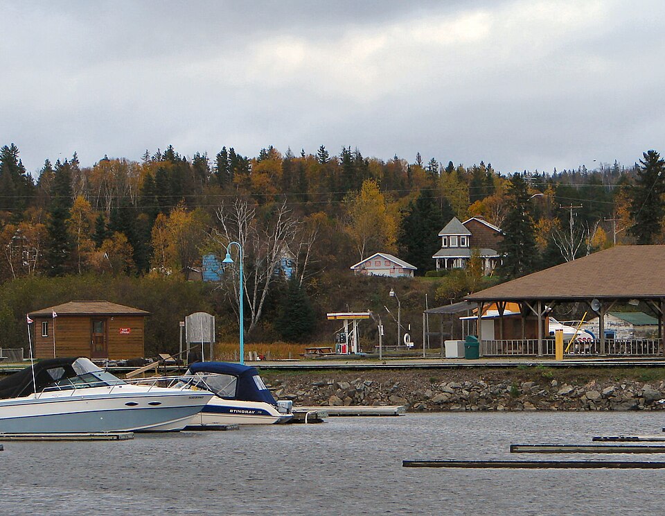
Michipicoten River Village waterfront,2007 P199 / Wikimedia Commons · Public domain — released by photographer
The exact record identifies the modern Michipicoten River Village in the Municipality of Wawa. The First Nation’s history explicitly describes the river-mouth village in its pre-relocation account. This modern municipal waterfront provides narrowly identified historical-place context; it is not the current GrosCap reserve village, a portrait of members, community-owned buildings or proof of territorial title. Unchanged complete record-linked960px full-frame preview. The larger original was not inspected or copied. CSS crops/overlays affect display only. The photographic image remains available under Public domain — released by photographer; creator/source/license credit retained. Parent imported the supplied complete JPEG unchanged; the recorded original/preview/earlier-derivative limits remain. CSS crops/overlays affect display only.
Image, association, and reuse record reviewed 2026-10-27.
Full photographs are displayed proportionally above. A translucent background copy may be cropped by the viewport; it does not replace the complete image or its record.
The visual treatment does not change the research status, evidence, or remaining gaps recorded in this profile.
Start reading here
A short starting path through selected actual-content works. Read each annotation for the specific community, period and inspection limits; this is not a complete history or community endorsement.
Continue with a community institution’s history of consultations and trust formation.
These are selected starting points. The full annotated collection, source perspectives, inspection limits and remaining research questions follow below. A starting guide is not an exhaustive history or community endorsement.
01
River connections and displacement
The First Nation’s public history describes the mouth of the Michipicoten River as a meeting and travel place. Its displacement account follows families through the river-mouth village, Half-Way and Green Acres before a return to a village on Gros Cap reserve. Keeping that sequence visible helps explain why community history extends beyond one administrative location. The account’s land grievances remain attributed to the Nation; the underlying surveys and title records require separate inspection.
The Community Trust’s2021 retrospective describes work begun in1997 to address several historical land claims together. It records consultation meetings with members on and away from the reserve before a2003 vote and trust arrangements. This gives readers a community institution’s account of participation and long-term planning. The retrospective is a route into further research, rather than a substitute for the actual agreements or a statement of present individual legal or financial entitlements.
Develop a community-directed history and annotated reading collection.
Review community-specific imagery and reuse terms before substantive profile publication.
Review detailed relationships, naming changes and historical regional connections.
Inspect original agreements, surveys and community records behind the selected histories.
Seek more member-authored public accounts, language materials and evaluations of later community projects.
Cohort06: selected actual-content sources and specifically scoped credited imagery form a bounded starting guide. Reused publications/photos are not new global works. Comprehensive history and community review remain open.
Follow the reading path
Sources & further reading
Open any title to read the original source. Annotations explain what each link can help you explore.
No Indigenous-led source is identified in this entry yet. This is a gap in this collection, and does not imply an absence of community knowledge or organization.
Read the complete public history, focusing on river connections and the Displacement section. The Nation’s account follows moves from the river-mouth village through Half-Way and Green Acres to Gros Cap. Historical labels and asserted land grievances remain attributed; underlying surveys, title records and every archaeological claim were not independently inspected. Current totals, sacred narratives and precise legal conclusions are excluded.
Inspection: Content reviewed for the stated scope
Scope: Read the complete public history, focusing on river connections and the Displacement section. The Nation’s account follows moves from the river-mouth village through Half-Way and Green Acres to Gros Cap. Historical labels and asserted land grievances remain attributed; underlying surveys, title records and every archaeological claim were not independently inspected. Current totals, sacred narratives and precise legal conclusions are excluded.
Review recorded: October 27, 2026
Access note: Substantial actual public article body read through the web reader; this is not an inspection of linked publications, photographs or underlying records. No login or reader paywall was encountered for the inspected text.
Read the full public history, including member consultations and establishment of the trust following the Algoma-claims settlement. A2021 institutional retrospective with dated1996–2003 events, not the actual settlement agreement or current legal/financial advice. Logo/teachings, individual entitlements, exact monetary totals and claimed present outcomes are not imported.
Inspection: Content reviewed for the stated scope
Scope: Read the full public history, including member consultations and establishment of the trust following the Algoma-claims settlement. A2021 institutional retrospective with dated1996–2003 events, not the actual settlement agreement or current legal/financial advice. Logo/teachings, individual entitlements, exact monetary totals and claimed present outcomes are not imported.
Review recorded: October 27, 2026
Access note: Substantial actual public article body read through the web reader; this is not an inspection of linked publications, photographs or underlying records. No login or reader paywall was encountered for the inspected text.