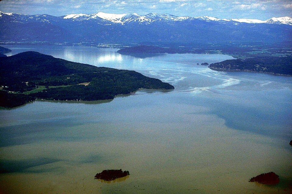
Lake Pend Oreille, Idaho — 1993 aerial landscapeU.S. Army Corps of Engineers, Lake Pend Oreille, 1993; Wikimedia Commons; U.S. federal public-domain work.
Kalispel is a reading route into a people whose historical communities are connected with the Pend Oreille region of Washington, Idaho and Montana. Start with the Kalispel Tribe of Indians’ own account, then compare an older regional history that distinguishes Upper and Lower Kalispel contexts. This introduction does not treat every historical community as the same present government.
See each region’s evidence for historical or present-day scope.
Homeland / region
Washington / Idaho / Montana
Research depth
Source guide
Source collection
3 annotated resources · 2 Indigenous-led
Inspected sources
2 substantive works · selected content reviewed
Initial adequacy
Still unfinished
Source review
October 27, 2026
A source guide for a deeper dive.This entry provides a brief orientation and an organized reading path. A comprehensive deep dive has not yet been completed. Follow the annotated sources and distinguish primary community accounts from outside reference material.
Still unfinished
A small, purposefully selected actual-content starting path and specifically scoped credited image are now available. Fuller history, source comparison and community review remain open; quantity does not establish completion.
Assessment recorded October 27, 2026. This is separate from research completion and community review.
Review Upper and Lower Kalispel histories through further community-directed sources, not only a regional compilation.
Inspect original removal, reservation and land records; current boundaries, legal status and population are not determined here.
Add fuller language, family and contemporary cultural accounts with appropriate public scope.
Backdrop photographs & credits
These photographs have individual, documented connections to this entry. Their captions and source records define the people, place, object, and period shown; no one photograph represents every community within a broader label.
Lake Pend Oreille, Idaho — 1993 aerial landscape U.S. Army Corps of Engineers, Lake Pend Oreille, 1993; Wikimedia Commons; U.S. federal public-domain work.
Lake Pend Oreille is expressly included in the Kalispel Tribe’s public homeland narrative and the selected older Kalispel chapter. The photograph is narrowly identified landscape context for this broader people-name reading route; it is not the Washington reservation, a current ownership map or proof of exclusive territory. Exact Commons media description, USACE source credit, 1993 date and U.S. federal-work public-domain statement were inspected. The complete provider-listed 960×641 preview was retrieved normally after a coordinated cooldown; its larger 1500×1001 source and the old USACE source server were not inspected. Parent imported the supplied complete JPEG unchanged; the recorded original/preview/earlier-derivative limits remain. CSS crops/overlays affect display only.
Image, association, and reuse record reviewed 2026-10-27.
Full photographs are displayed proportionally above. A translucent background copy may be cropped by the viewport; it does not replace the complete image or its record.
The visual treatment does not change the research status, evidence, or remaining gaps recorded in this profile.
Start reading here
A short starting path through selected actual-content works. Read each annotation for the specific community, period and inspection limits; this is not a complete history or community endorsement.
Compare the selected older Upper/Lower Kalispel narrative, retaining its dated limits.
These are selected starting points. The full annotated collection, source perspectives, inspection limits and remaining research questions follow below. A starting guide is not an exhaustive history or community endorsement.
01
Identity and homelands
Kalispel homelands extend along the Pend Oreille River, Lake Pend Oreille, and Clark Fork region.
The older Tribal Briefing Book distinguishes Upper and Lower Kalispel communities and describes different responses to settlement and removal. Its Kalispel chapter places Lake Pend Oreille within this wider history. Because it combines historical narrative with dated administrative information, it is useful for framing questions rather than establishing current leadership, landholdings or legal rights. Original records and fuller community histories remain important next steps.
The Kalispel Tribe of Indians’ public story links the loss of land and limited economic opportunities with efforts to build housing, education and community services. It presents a 1991 vision statement as part of that history. Read those goals in their stated historical setting; they do not demonstrate that every aspiration was fulfilled or describe all Kalispel communities in the same way.
Review Upper and Lower Kalispel histories through further community-directed sources, not only a regional compilation.
Inspect original removal, reservation and land records; current boundaries, legal status and population are not determined here.
Add fuller language, family and contemporary cultural accounts with appropriate public scope.
Cohort06: selected actual-content sources and specifically scoped credited imagery form a bounded starting guide. Reused publications/photos are not new global works. Comprehensive history and community review remain open.
Follow the reading path
Sources & further reading
Open any title to read the original source. Annotations explain what each link can help you explore.
No Indigenous-led source is identified in this entry yet. This is a gap in this collection, and does not imply an absence of community knowledge or organization.
GovernmentNorthwest Power Planning Council; hosted by GovInfoSource 1
Publication: Undated historical compilation; internal late-1990s references are not a verified publication date
Read the selected Kalispel historical narrative and the introduction to this older regional compilation. It distinguishes Upper and Lower Kalispel contexts. Dated administrative totals, officeholders, ceremonies and assertions about current legal rights are not adopted.
Inspection: Content reviewed for the stated scope
Scope: Introduction, PDF page 2 and selected narrative on printed/PDF pages 39–40 read; the Kalispel narrative begins at zero-based page 38. Other tribal chapters, fullvolume, underlying records and source images were not inspected. Its claim locating Albeni Falls Dam on the Kootenai River is erroneous and not repeated. End-of-century administrative listings are historical, not current.
Review recorded: October 27, 2026
Access note: Public GovInfo PDF actual selectable text inspected. Prior generic source card is explicitly upgraded with this documented review; URL and ID retained, publisher corrected from the earlier generic attribution.
Publication: Undated; access date is not a publication date
The Tribe’s own account connects history, community wellbeing and its relationship with the Pend Oreille country. The1991 vision is an aspiration, not proof that every goal was later realized.
Inspection: Content reviewed for the stated scope
Scope: Complete public main body lines 33–76 read, including historical hardship, the explicitly aspirational1991 vision statement and homeland/reservation narrative. Present totals, business counts, income, population and legal land status were not adopted.
Review recorded: October 27, 2026
Access note: Actual selected public content inspected without account or subscription; linked original records, media and cited publications remain outside this review unless expressly stated.
Related entries may represent alternate names, constituent communities, wider groupings, or historical connections. Read the naming notes before treating entries as equivalent.
Robey’s Atlas of Indigenous North America · Compiled October 19, 2026 · Kalispel