Dokis First Nation’s relationship with the French River is a useful starting point for learning about its community-directed energy and land-management work. A community-approved case study and a detailed interview with its lands administrator document particular projects and their limits.
See each region’s evidence for historical or present-day scope.
Homeland / region
Ontario, Canada — Lake Huron region member listing
Research depth
Source guide
Source collection
2 annotated resources · 1 Indigenous-led
Inspected sources
2 substantive works · selected content reviewed
Initial adequacy
Still unfinished
Source review
October 27, 2026
Names & relationshipsListed as an Anishinabek Nation member First Nation. Membership alone is not treated as proof of Ojibwe, Anishinaabe or other ethnic identity.
A source guide for a deeper dive.This entry provides a brief orientation and an organized reading path. A comprehensive deep dive has not yet been completed. Follow the annotated sources and distinguish primary community accounts from outside reference material.
Still unfinished
A small, purposefully selected actual-content starting path and specifically scoped credited image are now available. Fuller history, source comparison and community review remain open; quantity does not establish completion.
Assessment recorded October 27, 2026. This is separate from research completion and community review.
Expand community-authored historical and language sources beyond these selected development and lands accounts.
Compare project benefits with later community assessments and original reports rather than treating the case study as an audit.
Review original survey and environmental work separately; this guide does not determine boundaries, current legal authority or sensitive sites.
Backdrop photographs & credits
These photographs have individual, documented connections to this entry. Their captions and source records define the people, place, object, and period shown; no one photograph represents every community within a broader label.
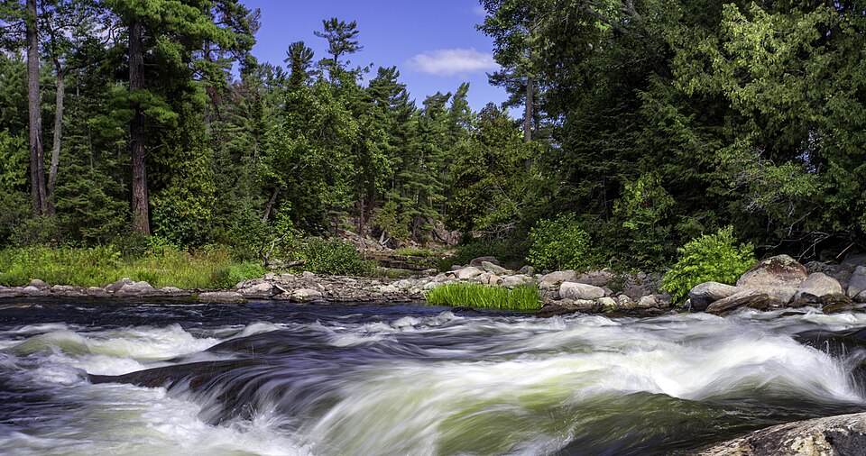
French River rapids, September 2015 Eric Raymond Lanning · 2015-09-13 · CC BY 3.0, via Wikimedia Commons.
The photographer’s caption is simply Rapids; the inspected Commons record categorizes it as French River/Dokis context. The community-approved Dokis case study establishes the community’s relationship to the French River. This is regional waterway context only, not an independently verified reserve location, the hydroelectric project, a ceremonial place or territorial evidence. Exact source record, photographer and media-specific licence read; no image-based historical source count. Parent imported the supplied complete JPEG unchanged; the recorded original/preview/earlier-derivative limits remain. CSS crops/overlays affect display only.
Image, association, and reuse record reviewed 2026-10-27.
Full photographs are displayed proportionally above. A translucent background copy may be cropped by the viewport; it does not replace the complete image or its record.
The visual treatment does not change the research status, evidence, or remaining gaps recorded in this profile.
Start reading here
A short starting path through selected actual-content works. Read each annotation for the specific community, period and inspection limits; this is not a complete history or community endorsement.
Follow an attributed explanation of contemporary lands work and learning opportunities.
These are selected starting points. The full annotated collection, source perspectives, inspection limits and remaining research questions follow below. A starting guide is not an exhaustive history or community endorsement.
01
Community decisions and a hydro partnership
The 2024 Okikendawt case study presents hydroelectric development as a long-term Dokis initiative involving community meetings, successive leaders and a partnership with Hydromega. Its methods explain that Dokis reviewed the account and held final approval. The report links the project with planning for community benefits. This supplies a community-approved perspective; it does not independently establish every financial or environmental outcome.
In a 2025 interview, lands administrator Randy Restoule explains how Dokis uses drones and geographic information systems to obtain updated imagery and investigate changes along the French River. He also describes opportunities for young people to learn field and computer skills. These are his dated accounts of work and plans. The underlying measurements and individual property questions were not independently reviewed here.
Develop a community-directed history and annotated reading collection.
Review community-specific imagery and reuse terms before substantive profile publication.
Review detailed relationships, naming changes and historical regional connections.
Expand community-authored historical and language sources beyond these selected development and lands accounts.
Compare project benefits with later community assessments and original reports rather than treating the case study as an audit.
Review original survey and environmental work separately; this guide does not determine boundaries, current legal authority or sensitive sites.
Cohort06: selected actual-content sources and specifically scoped credited imagery form a bounded starting guide. Reused publications/photos are not new global works. Comprehensive history and community review remain open.
Follow the reading path
Sources & further reading
Open any title to read the original source. Annotations explain what each link can help you explore.
No Indigenous-led source is identified in this entry yet. This is a gap in this collection, and does not imply an absence of community knowledge or organization.
Reporting / interviewIndigenous Clean Energy / Indigenous Peoples Rights International / Business & Human Rights Resource CentreSource 1
October 2024 case study, PDF pp.1–5 actually read: project background, methods, community involvement and decision making. Its methods state that Dokis held final edits and approvals. An affirmative project account, not an independent audit; financing records, underlying votes and environmental outcomes were not independently verified.
Inspection: Content reviewed for the stated scope
Scope: PDF pages1–5, selected complete sections1–7: executive summary, background, methods, project overview, community setting and decision-making.
Review recorded: October 27, 2026
Access note: Public actual-content body/PDF selected pages were read without a login. October2024 affirmative case study by project/Indigenous/rights partners. Methods state Dokis held final edits/approvals. Underlying votes, finance, agreements, trust records and environmental audit not independently inspected. No sensitive practices or sites reproduced.
Complete May 14, 2025 article read, with particular attention to Randy Restoule’s explanation of drone/GIS work, historical-water-level research and youth opportunities. An attributed interview, not independently inspected survey data or a determination of property boundaries. Sensitive site and burial details are not reproduced.
Inspection: Content reviewed for the stated scope
Scope: Complete May14,2025 main article and RandyRestoule interview, web body lines3–57; selected synthesis uses lands technology and youth-learning discussion.
Review recorded: October 27, 2026
Access note: Public actual-content body/PDF selected pages were read without a login. Journalist’s attributed interview, not original GIS datasets, surveyor/legal determination or verified later plans. Sensitive archaeological/burial details and exact survey/property anecdotes excluded.